By Chris Johnson, VP of Spatial Risk Intelligence, EarthDaily
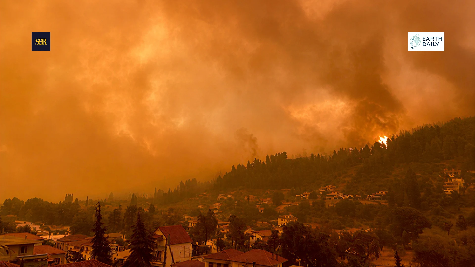
VANCOUVER, March 10, 2026 — In early 2025, fires moved into dense neighborhoods in Southern California, leading to roughly USD 40 billion in insured losses, according to Swiss Re. The scale of the damage was shaped not only by fire intensity, but by the catastrophic conflagration that occurs when wildfires reach concentrated urban assets.
Canada has seen its own version of this shift. In 2023, more than 17 million hectares burned, the highest seasonal total on record. Statistics Canada recorded evacuations and disruption across multiple provinces. By mid-2025, the area burned was again running above historical norms.
This pattern is becoming familiar and points to a landscape defined by increasingly dry soil conditions and dangerous fuel accumulation—transforming wildfire from an episodic environmental hazard into recurring, systemic level business risk. This also exposes a growing mismatch between how landscapes are changing and how wildfire risk is currently being evaluated.
Beyond Boundaries: Why Forests, Cities, and Farmland Now Form a Singular Systemic Risk Corridor
That mismatch becomes most visible when forests, cities, and farmland are viewed not as separate zones, but as part of the same evolving risk system.
Canada’s boreal forest runs across much of the country, next to towns, highways, and critical infrastructure. In the United States, forests often edge up against growing cities and farmland, with over a third of American homes now falling inside wildfire-prone areas.
The line between the Wildland Urban Interface (WUI) and infrastructure is vanishing. Persistent heat and drought along with a dangerous accumulation of fuel loads, coupled with prolonged soil moisture deficits, are fundamentally escalating the systemic risk of wildfire.
From a monitoring perspective at EarthDaily, we observe that this environmental shift has moved past gradual change into a state of volatility. Satellite-based time-series data reveal that fuel buildup and vegetation stress are diverging sharply, with neighboring areas showing contrasting risk profiles within a single season.
That kind of variability makes traditional containment assumptions harder to rely on. Fires that originate in forests now move rapidly into peri-urban and urban environments, as seen repeatedly in California. Swiss Re has linked recent wildfire losses not just to climate conditions, but to the concentration of assets sitting inside these evolving landscapes.
Agricultural regions are part of this shift as well. The damage is not limited to fields that burn. Smoke can depress yields and taint harvests. Power outages interrupt irrigation and storage. Road closures and evacuations disrupt labor and transport just as crops are moving through tight seasonal windows. Satellite monitoring reveals that environmental stress extends far beyond the active burn perimeter; increased fuel loads and prolonged soil moisture deficits layer on top of heat cycles in a way that affects loss.
Why Traditional Models Fall Behind
For years, wildfire risk was assessed through a historical lens, where burn scars, event footprints, and static wildfire tools defined our understanding of exposure. In an era when landscapes shifted slowly and fuel conditions followed predictable seasonal cycles, this approach provided a more reliable proxy for risk.
Old assumptions no longer hold. Warmer temperatures, extended dry periods, and repeated stress events are altering fuel and moisture patterns across regions. Fuel dries unevenly and sooner than expected. Vegetation that once recovered between seasons now remains weakened for longer stretches. While the pace and severity of drying differ by region, prolonged heat causes soil moisture to remain at deficits well beyond historical seasonal windows increasing wildfire risk.
Static maps and historical data fail to capture these evolving environmental shifts leaving a dangerous gap between legacy risk assessments and current dynamic conditions on the ground.
Addressing this gap requires a model that begins with how the environment is changing. This requires calibrated, frequent environmental insight into fuel conditions, vegetation stress, moisture, terrain, and weather — integrated in a way that updates as landscapes change.
EarthDaily’s Ascend platform is built around that principle, combining optical, radar, elevation, land-cover, moisture, and atmospheric datasets into a unified environmental view.

Burn severity map of the 2025 Henry Fire in the Topanga-Pacific Palisades area of Southern California, illustrating burn intensity from low to very high across the footprint (EarthDaily Ascend analysis).
The upcoming EarthDaily satellite constellation is designed to extend this capability. It will provide daily global coverage across 22 spectral bands, including those sensitive to vegetation stress and surface moisture. By mid-2026, the Constellation will enable consistent, high-cadence tracking of fuel conditions over time, providing data needed to analyze risk across the globe.
Wildfire Risk is No Longer One-Dimensional
Understanding how susceptibility forms is only part of the equation; the greater challenge lies in recognizing that wildfire risk has evolved into a complex, systemic threat that transcends traditional boundaries.
The most visible is direct physical damage -- to homes, infrastructure, equipment, and crops. This remains the focus of most preparedness efforts and insurance coverage, but it is only one component of the loss profile.
Disruption often shows up before physical damage. Evacuations, power shutoffs, transport disruptions, and heavy smoke can bring work to a standstill even when buildings remain intact. In many cases, operations are interrupted before any physical damage occurs.
Wildfire losses have been accumulating for years. Global economic damages over the past decade exceed US$ 100 billion. By mid-2025, insured catastrophe losses had already reached about US$ 80 billion worldwide, with U.S. wildfires representing a significant portion.
In response to escalating risks, insurers are raising premiums, increasing deductibles, or restricting coverage, with some areas becoming entirely uninsurable. These shifts transcend insurance contracts, directly impacting lending terms, property valuations, and long-term capital planning.
Wildfire is also emerging as a governance and disclosure issue. Boards, lenders, regulators, and communities are asking not only how organizations respond to fires, but how they account for evolving environmental risk.
As wildfire losses mount, legacy hazard maps have become unreliable, necessitating a fundamental shift in how we approach risk mitigation.
Shifting from Response to Prevention
While defensible space, fuel management, and emergency response planning remain essential, traditional wildfire models are not designed to monitor the changing fuel loads, soil moisture and weather. In today’s high-risk environment, dangerous conditions materialize long before the first ignition.
Managing risk now means changing the way we think about wildfire. We need to change our approach from static to a dynamic view. In practice, this can involve updating risk assessments more often, stress-testing operations against supply chain or basic business risk, and revisiting insurance and financing assumptions as environmental signals shift.
At EarthDaily, we leverage data science and frequent updates to show elevated risk well before others.
While climate change is fundamentally destabilizing all peril categories, wildfire has emerged as a major business, environmental and human challenge. It remains a critical factor in infrastructure resilience, Property & Casualty (P&C) coverage availability and governments responsibility to public safety. Because static classifications no longer capture these accelerating shifts, operational discipline now requires dynamic change detection and mitigation strategies that adapt to conditions on the ground.
Across North America, wildfire conditions are shifting in ways that legacy risk models—many, still used by insurers, utilities, and governments—were never built to anticipate. These effects are no longer confined to remote wilderness; they are increasingly impacting urban centers, agricultural lands, and exerting a significant negative impact on finance, GDP, business continuity and the safety of our citizens.
About Chris Johnson
Chris Johnson is VP of Spatial Risk Intelligence at EarthDaily, where he leads strategy and growth for geospatial risk solutions supporting insurance, government, and enterprise markets. He brings extensive experience building and scaling SaaS businesses, developing high-performing teams, and driving operational performance across product, sales, and customer delivery.


 sme.webp)
FT (1).webp)
 ft (2).webp)
 ft.webp)
 ft.webp)
 ft.webp)
 ft.webp)
 ft.webp)