By Sarah Grelik, Director of Data Science, Spatial Risk Intelligence at EarthDaily
VANCOUVER, Feb. 26, 2026 — Every major property decision, whether it involves insurance coverage, financing, valuation, or compliance, begins with a simple question: where is the asset?
In most systems, that question is answered quickly. A property’s location is resolved through a geocoding process, assigned a coordinate, and then carried forward through risk workflows. Once that coordinate enters a pipeline, it is reused across hazard models, reporting cycles, and portfolio summaries, even when other datasets would place the same address differently.
For individual properties, the implications may be limited. When you look at one building, the difference can seem minor. When you look at ten thousand, it isn’t. One dataset places a property just inside a flood boundary, while another places it just outside. The map looks almost identical, but the classification does not.
Across the global P&C insurance industry, geocoding errors remain widespread enough to materially affect underwriting accuracy, portfolio analysis, and catastrophe modeling.
As portfolios get larger and risk systems run automatically, those small placement differences show up in reports, pricing models, and exposure summaries. Differences measured in meters can influence how risk is aggregated, priced, and communicated across large asset bases.
The Expanding Scope of Property Risk
Property risk now sits much closer to capital decisions than it did a decade ago. It shows up in lending terms, underwriting reviews, board conversations, and investor disclosures.
The numbers explain why. Recent years have pushed insured catastrophe losses past USD 100 billion, with floods and wildfires accounting for a growing share. Development activity remains steady in river basins, wildfire-prone regions, and coastal areas. Property portfolios are carrying more exposure as a result.
To manage this growing scope, property risk assessment relies on standardized, automated workflows. Underwriting, exposure analysis, and aggregation operate continuously across thousands or millions of assets. These systems are designed for consistency and efficiency. Once inputs are standardized, they tend to remain in place.
That persistence gives location assumptions lasting influence, because every downstream calculation depends on how assets are placed in space, including:
1) A property’s position relative to floodplains or wildfire buffers
2) Exposure aggregation across portfolios and regions
3) Pricing, insurance, and risk transfer decisions
Location functions as the reference layer for these decisions.
Location Assumptions in Portfolio Decisions
Geocoding is widely treated as a settled technical input. In practice, it remains one of the more variable elements in property risk analysis.
Two geocoding providers can return slightly different coordinates for the same address. The difference may come down to how the point is placed -- at the center of a parcel, on a rooftop, or along a street segment.
On a map, the shift is barely noticeable. It becomes visible when that location is checked against a flood map or a wildfire buffer. A few meters one way and the property sits inside the boundary. A few meters the other way and it does not. That placement follows the asset through the rest of the analysis.
Across a large book of business, those small inside-or-outside calls start to add up. By the time everything is rolled into a portfolio view, no one is thinking about the original placement anymore.
Modern property risk workflows typically ingest a location once and reuse it across hazard models, time horizons, and reporting cycles. That coordinate becomes the reference point for exposure calculations and loss projections. If the placement carries uncertainty, the uncertainty carries forward with it.
The impact shows up in:
1) Exposure summaries that shift with small location changes
2) Loss estimates that vary depending on boundary placement
3) Disputes that emerge late in underwriting or review
This can be seen most clearly when those numbers reach pricing models, capital committees, reinsurance negotiations, or investor reporting.
Accurate Geocoding as Decision Infrastructure
Within this context, some risk teams are approaching geocoding as a process of reconciliation rather than a single lookup.
EarthDaily’s Geocoding Consensus Algorithm reflects this approach. It evaluates multiple independent geocoding results for the same property, examining where they align, where they diverge, and how much confidence can reasonably be placed in the resulting location. The output includes both a coordinate and an indication of certainty.

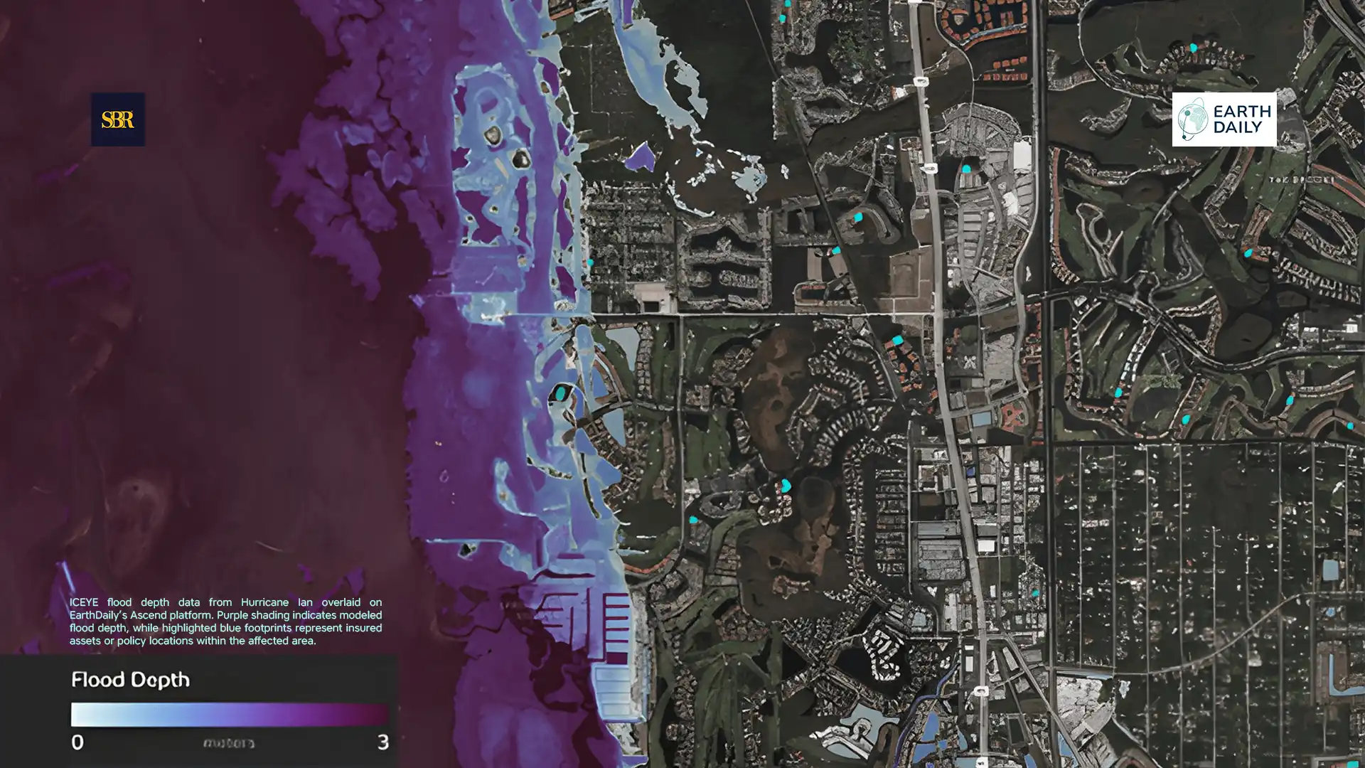
Original carrier policy location (left) indicated no flooding. EarthDaily’s corrected geocoded location places the asset at the building footprint and shows 0.92 m of flooding. The discrepancy stems from a 114 m geocoding error that positioned the asset on the road in front of the building. Flood extent shown in blue is derived from ICEYE data from Hurricane Ian.
In property risk workflows, this enables teams to distinguish between assets where location confidence is strong and those that warrant additional review before being incorporated into automated models. That visibility supports more consistent decisions across portfolios, where small inconsistencies can compound.
Property risk makes these dynamics visible because outcomes depend on mapped boundaries. Flood zones, wildfire buffers, and zoning overlays define exposure through geographic lines. A property’s position relative to those lines drives classification and pricing, and disputes often follow from that placement.
As climate volatility increases and property risk decisions receive closer scrutiny, more attention is being paid to how exposure is determined in the first place. Location shapes how exposure is measured, how risk is aggregated, and how capital is allocated. The quality of geocoding therefore becomes part of the risk framework itself. Treating geocoding as core infrastructure strengthens pricing, capital planning, and risk transfer decisions.
Within this context, some risk teams are approaching geocoding as a process of reconciliation rather than a single lookup. EarthDaily’s Geocoding Consensus Algorithm reflects this approach. It evaluates multiple independent geocoding results for the same property, examining where they align, where they diverge, and how much confidence can reasonably be placed in the resulting location.
About Sarah Grelik
Sarah Grelik is Director of Data Science, Spatial Risk Intelligence at EarthDaily. She leads the spatial risk data science team focused on improving insurance risk and exposure through location intelligence and remote sensing.


FT.webp)
FT.webp)
FT.webp)
FT.webp)
FT.webp)
FT.webp)

.webp)